
- Orson Martin’s Factory Bottom
- Crossing Lower Howard’s Creek
- Hieronymus Cabin
The mouth of Lower Howard’s Creek lies in the palisaded area of the Kentucky River, and the creek cuts through a limestone gorge on its way to the river. Because of these cliffs, the creek was a barrier to travel in pioneer settlement times. Early residents described the paths they used to cross the creek. Ambrose Bush stated that he “had been accustomed to pass at the different crossing places at or near the mouth of lower Howards creek & the traces leading up the cliffs for upwards of thirty years (i.e., the traces leading from McGees & Holders Stations to Boonesborough & Bush’s settlement) & that he never saw but two. I used to ride up & down them to mill & knew them most intimately.”
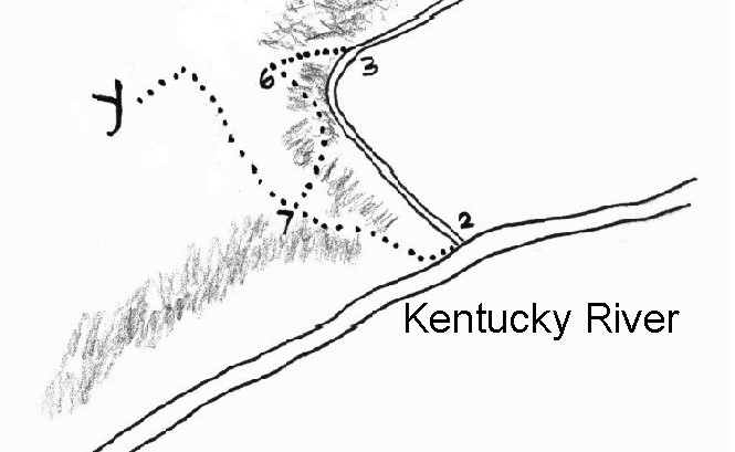
One of these traces, used at times of low water, crossed the creek near the mouth. The cliff on the west side was ascended on a steep but passable path. As shown on the map below, this trail crossed the creek at 2, went up the cliff to 7 then continued past Y to Holder’s Station and various mills. (The cliffs are indicated by cross-hatching.) Much of this trail was destroyed during the construction of Athens-Boonesboro Road.

Taken from a map prepared in the lawsuit Holder’s heirs v. Jouett’s heirs.
When water was high, the creek could be crossed at a shoal upstream, 3 on the map. This crossing was in the area behind the rear parking lot at Hall’s Restaurant. One could ascend the cliff on the west side by a gentle path leading to 6, which is near the site of Harry Pritchard’s 20th-century homestead (to be discussed in a future article). 6 · · · 7 is a bench that winds its way back toward the trail that crossed near the mouth. Whitson George testified that he had “passed along this old trace numberless times, as in times of high water it was his road home from Holder’s Warehouse, where he has been a principal inspector upwards of sixteen years.” The path labeled 6 · · · 7 is now a portion of the John Holder Trail in Lower Howard’s Creek Nature & Heritage Preserve.
Lower Howard’s Creek played an important role in early Clark County history. Its waters powered so many industries that Dr. Thomas D. Clark referred to it as the place where Kentucky’s moneyed economy began. Because money, or specie, was in such short supply on the frontier, pioneer farmers bartered their surplus produce for store-bought goods. Winchester’s first newspaper carried frequent advertisements from businesses offering to sell their merchandise in exchange for a wide variety of items (tobacco, bacon, whiskey, linen, wool, feathers, etc.).
That began to change when the Mississippi River was opened for commerce. Goods produced at Lower Howard’s Creek industries could be shipped to market in New Orleans, whose merchants paid cash money. John Holder’s ventures at the mouth of the creek—a tavern, ferry, inspection warehouse, and boatyard—made this a destination for products produced in the mills, distilleries, and factories along Lower Howard’s Creek.
I thought this would have been an early crossing, given the need to connect the Bush Settlement on the east side of the creek with John Holder’s facilities on the west side. The first mention in county road orders was a 1795 petition from local citizens for “a bridle way to be opened from Boonsborough Ferry Down the River to Holders Road that Leads from Holders Ferry to Lexington.” Apparently, neither a wagon road nor a bridge was feasible on this route in early times, so a horse trail was requested, and granted.
For many years, the main path from the Bush Settlement to Holder’s place crossed Lower Howard’s Creek just above the Old Stone Church, proceeded north to what is now McClure Road, then west to Becknerville Road and south on Combs Ferry Road to the river. The arduous journey required explains why we had two ferries (Boonesborough and Holder’s) and two inspection warehouses (Bush’s and Holder’s) located just over one mile apart.
It would be more than a century after the first settlement before the first bridge was built across the mouth of Lower Howard’s Creek. In 1883 the county court approved a new road to run 1.4 miles from the Boonesborough Ferry landing to the creek, the first section of Athens-Boonesboro Road (KY 418). The county was to pay the costs of opening the road, including a bridge. The 30-foot-wide path was cleared of trees and brush and macadamized. In 1886, the county contracted for a 190-foot-long iron bridge, estimated to cost $3,100. James D. Lisle inspected the finished turnpike and reported to the court, “The grades are easy, enough metal [rock] put on and well broken, it is altogether one of the best pieces of work in the County.”
It seemed unusual that this important artery across Lower Howard’s Creek was not constructed until 1886. However, Boone, Jouett, Fourmile, and Upper Howard’s Creeks do not have a bridge at their mouth. Lower Howard’s Creek actually turns out to be an exception.