
I confess to an enduring fascination with Daniel Boone and still read everything I can get my hands on about him. He is best known to Kentuckians as the skilled woodsman responsible for the settlement of Boonesborough in 1775. More importantly for us, he left his footprints all over Clark County. The title and topic of this essay were suggested by Nancy Turner, our former tourism director, before she fled to join the high muckety-mucks in Frankfort. This is an effort to identify the most important documented Boone sites in Clark County.
The sites below with an asterisk are marked with a Kentucky Historical Marker.
*Indian Old Fields
Reputed site of the Shawnee village Eskippakithiki shown on Lewis Evans’ 1755 map and situated along the Great Warrior’s Path. Located about 11 miles southeast of Winchester. Comprises 3,500 acres of fertile plain that Native Americans had occupied for several thousand years. The celebrated Shawnee chief, Catahecassa (Black Hoof), visited his former home here in 1816.
*Pilot Knob
This site in nearby Powell County is thought to be where Boone and his company of longhunters got a view of Indian Old Fields. According to his biography in John Filson’s Discovery, Settlement and Present State of Kentucke, Boone stated, “On the seventh day of June [1769], we found ourselves on Red-River, where John Finley had formerly been trading with the Indians, and, from the top of an eminence, saw with pleasure the beautiful level of Kentucke.”
*Lulbegrud Creek
Daniel Boone and his party of explorers camped on this branch of Red River in 1770. According to Boone, they had taken along a copy of Jonathan Swift’s Gulliver’s Travels for their amusement. They gave the creek the name of the town visited by Mistress Glumdalclitch called “Lorbrulgrud.” The spelling was soon corrupted to “Lulbegrud.”
Log Lick
According to a deposition by Boone, Log Lick took its name from a salt lick where William and Major Beasley had cut down trees (1775) to help trap buffalo for hunters. Located somewhere in the neighborhood between Log Lick Road and Lulbegrud Creek.
*Salt Spring Trace
One of the first marked trails in Kentucky (1775). The path began at Fort Boonesborough, crossed the Kentucky River at Blackfish Ford, and followed a buffalo trace up Lower Howard’s Creek before turning north and continuing on to the Lower Blue Licks, where Boone and the first settlers made salt and hunted buffalo. Boone likely discovered the path on his longhunt in 1769–70. It was the trace used by Boone and his salt makers when they were captured by the Shawnee in 1778.
*Boone’s Settlement
Boone was awarded a 400-acre settlement plus 1,000 acres adjoining, located in the Schollsville area, for growing a crop of corn in 1775 and 1776. He claimed the tracts at the Virginia Land Commission held at Boonesborough in December 1779 and later sold the land to William Scholl. Two of Boone’s daughters—Lavina Scholl and Rebecca Goe—were buried here.
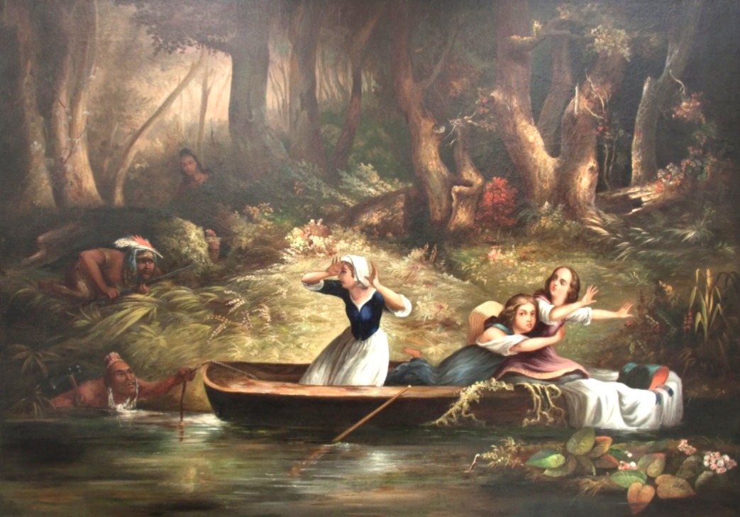
*Boone-Callaway Girls Kidnapping
On a Sunday afternoon in July 1776, Daniel Boone’s daughter Jemima and Richard Callaway’s daughters Betsey and Fanny left Fort Boonesborough to canoe on the Kentucky River. They drifted close to the opposite bank near the present bridge and were captured by five Native Americans and taken north. Boone pursued them with eight men and rescued the girls unharmed two days later on Cassidy Creek in Nicholas County. One of the iconic events of the early Kentucky frontier.
*Daniel Boone, Surveyor—Bush Settlement
Never miss a thing with our FREE weekly newsletter.
Daniel Boone earned substantial income as a land surveyor (1783−1797). The first eleven surveys he conducted for Captain Billy Bush in Clark County served as the basis for the Bush Settlement. The first was made on January 7, 1783. In all, Boone surveyed a little over 6,000 acres for Bush, who had located the land for himself and others.
Boone Creek
This Kentucky River tributary, which marks the boundary between Fayette and Clark County, was named for Daniel Boone. According to Boone, he became acquainted with the creek in 1775 when locating and filing land claims for James Hickman.
The following items are not historical sites but rather tributes to the memory of Daniel Boone in Winchester. A statue of Boone, carved in 1933 by A. D. Fisher, stands today at College Park in Winchester. A Boone mural by Kevin Osbourn appears on the side of the building at 21 North Main Street. The Clark County Courthouse has a Boone bust and a painting of Boone on Pilot Knob, both executed by Jack Hodgkin.