
Combs Ferry has had several different connotations in Clark County. First, and most obviously, it was once a ferry on the Kentucky River. Later, Combs Ferry Road and, finally, a community called Combs Ferry were established. Each has played a role in Clark County’s history.
The Ferry
In the 1790s, at the mouth of Lower Howard’s Creek, Col. John Holder operated a warehouse where tobacco and flour barrels were inspected and stored, a boatyard where he built flatboats for carrying county produce downriver to New Orleans, and a Kentucky River ferry that provided access to goods from Madison County. His enterprises were on the west side of the creek, across from Hall’s Restaurant.
After his death, his son-in-law, Samuel R. Combs, acquired Holder’s businesses, which he continued to operate as Combs Warehouse, Combs Boatyard, and Combs Ferry.
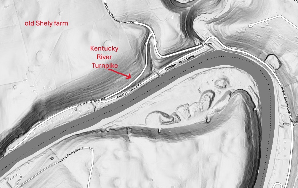
After Combs’ death, James T. Woodward purchased the ferry. In 1858, Woodward received permission from the county court to re-establish the ferry about three-quarters of a mile downstream, to the end of present-day Amster Grove Road. Daniel Bentley ran the ferry for Woodward, and in 1869, he purchased the ferry from Woodward’s heirs.
Combs Ferry remained in operation under a series of owners until the mid-twentieth century. The ferry landing is still visible on both sides of the river¾on Amster Grove Road on the Clark County side and on the Col. David J. Williams Firing Range on the Madison side.
The Road
Combs Ferry Road was originally named Holder’s Road, which ran from the ferry landing to the Bourbon County line; from there it went on to Paris by way of present-day Clintonville. The road’s name was changed after Combs acquired the ferry. At that time, it was an essential link in the road from Paris to Richmond.
Never miss a thing with our FREE weekly newsletter.

In 1857, the Combs Ferry Turnpike Company completed a macadamized road from Becknerville to the Kentucky River. Combs Ferry Turnpike provided access to the new ferry landing. It was soon renamed the Kentucky River Turnpike. On the descent to the river, the turnpike was at a slightly higher elevation than the current Amster Grove Road. There is still a Combs Ferry Road on the Madison County side that connects the old ferry landing at the police firing range with the road to Richmond (KY 627).
Today, Combs Ferry Road begins at a fork in Athens-Boonesboro Road and proceeds north to Becknerville, where it turns west and runs about 5 miles to Lexington Road (US 60).
The Community
The community of Combs Ferry was established when a road was extended to the new ferry landing and soon became a lively neighborhood. In addition to the ferry, the riverfront area had several stores and homes, a distillery, a steam-powered saw and grist mill, and a post office.
In the 1920s, longtime Combs Ferry resident and storekeeper Zol Amster acquired 22 acres of land between the ferry landing and the mouth of Lower Howard’s Creek and divided it into 76 building lots for homes and river camps. The new Amster Grove Road and Amster Grove Court provided access to the lots (present-day Amster Grove Court and Hidden Grove Lane were originally one road). The area, rechristened Amster Grove, was soon fully developed and became a frequent site of river parties, family reunions, and club meetings. Then as now, periodic Kentucky River floods wreaked havoc on riverfront properties.
Subsequent articles will flesh out more details of Combs Ferry and Amster Grove.